Floodplain and Soil Data
Floodplain Information:
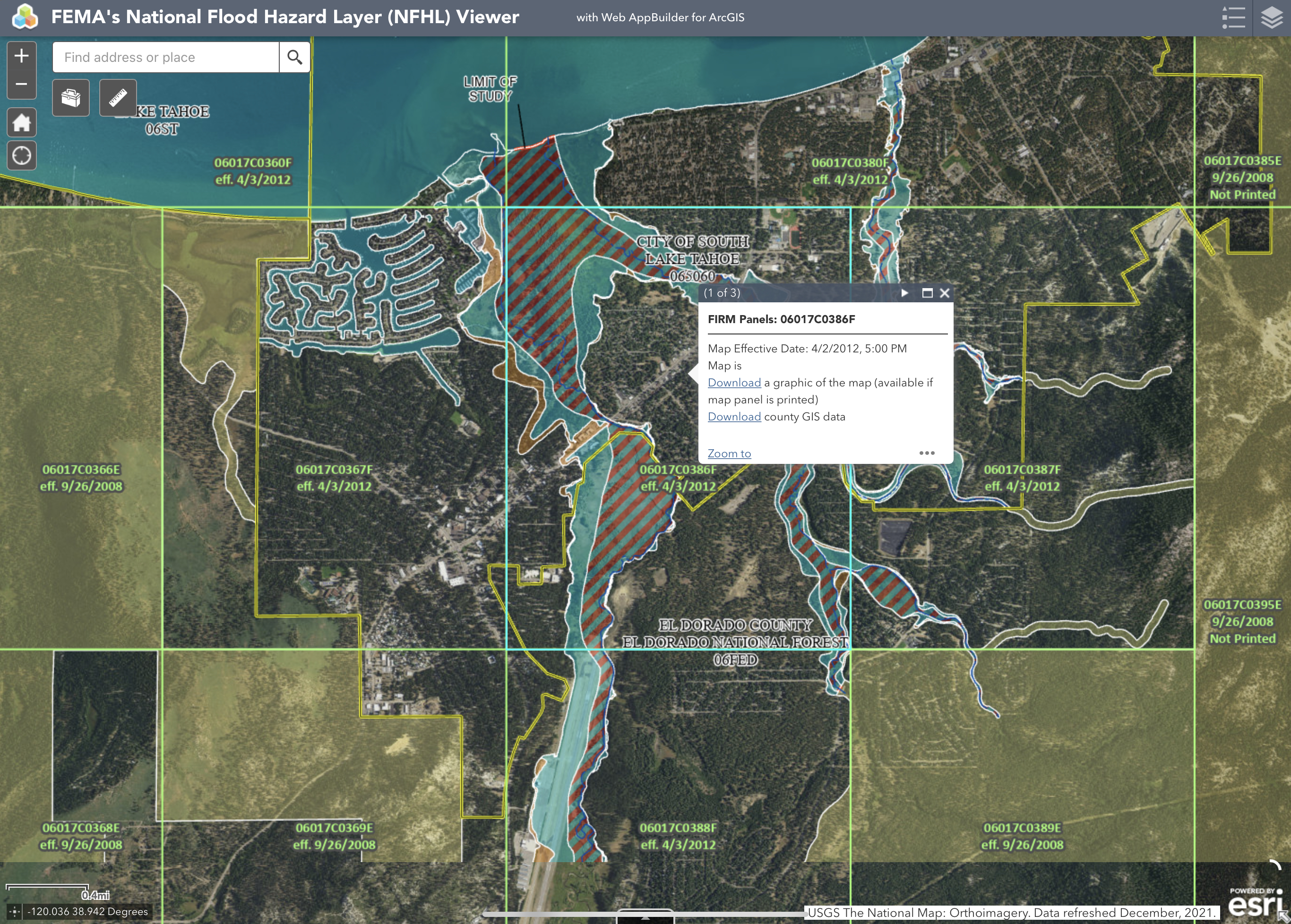
The area of the Upper Truckee River Watershed that I am analyzing is the area between the Upper Truckee River and Trout Creek. This area is known as the Truckee River Marsh area. One would think that an area situated between two bodies of water would be subject to flooding. However, as shown in the image below, this area is designated as FEMA flood zone X, which represents an area of minimal flood hazard (FEMA, 2021). Zone X has a 0.2 percent annual chance of flood (FEMA, 2020).
Soil Data:
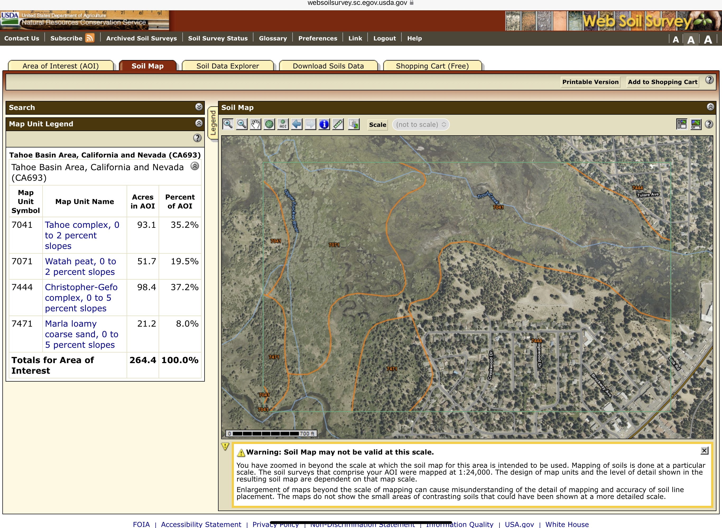
This area of the Upper Truckee River Watershed is characterized primarily by Tahoe complex and Christopher-Gefo complex soils (USDA, 2019). Other soils include Watah peat and Marla loamy coarse sand. Tahoe complex soil occurs at 0 to 2 percent slopes, is found at elevations of 6,220-7,970 feet, has very poor drainage, and is not classified as prime farmland. Christopher-Gefo complex soil occurs at 0 to 5 percent slopes, is found at elevations of 6,220-6,410 feet, has good drainage, and is considered farmland of statewide importance. Watah peat occurs at 0 to 2 percent slopes, is found at elevations of 6,220-9,410 feet, has very poor drainage, and is not considered prime farmland. Marla loamy course sand occurs at 0 to 5 percent slopes, is found at elevations of 6,220-6,490 feet, has poor drainage, and is not considered prime farmland. The image below shows the soil compositions and locations of soils in the Upper Truckee River Marsh area.
Other Floodplain Data:
The lowest monthly average temperature of the Upper Truckee River occurs in December at a temperature of 0.6 degrees Celsius (33.08 degrees Fahrenheit), while the highest monthly average temperature is 14.6 degrees Celsius (58.28 degrees Fahrenheit) in August (USDA, 2022). The lowest monthly discharge rate of water from the Upper Truckee River is in September at a rate of 8.6 cubic feet per second, while the highest rate occurs in May at a rate of 264 cubic feet per second.
The Upper Truckee River Marsh area is classified as a channeled meadow stream environment zone by the Tahoe Regional Planning Agency (Tahoe Regional Planning Agency, 2020). The figure below shows the conditions of stream environment zones in the Upper Truckee River Marsh area. The area closest to Trout Creek, in green, is generally stable while the area closest to the Upper Truckee River, in red, is very unstable. The Trout Creek side has some development in the historic meadow and floods frequently. Part of the Upper Truckee River side was restored in 2001 as part of the Lower West Side restoration project, and much of the original meadow was lost to development.

Sources:
FEMA. 2020. Flood Zones. Available at: https://www.fema.gov/glossary/flood-zones.
FEMA. 2021. National Flood Hazard Layer. Available at: https://www.fema.gov/flood-maps/national-flood-hazard-layer.
Tahoe Regional Planning Agency. 2020. Lake Tahoe Basin Stream Environment Zone (SEZ). Available at: https://gis.trpa.org/TahoeSEZViewer/SEZ baseline condition assessment_v8.pdf.
USDA. 2019. Web Soil Survey. Available at: https://websoilsurvey.sc.egov.usda.gov/App/HomePage.htm.
USDA. 2022. USGS Surface-Water Monthly Statistics for the Nation. Available at: https://waterdata.usgs.gov/nwis/monthly?referred_module=sw&site_no=103366092&por_103366092_102818=172692,00010,102818,1997-10,2003-09&site_no=103366092&por_103366092_102819=172692,00060,102819,1990-06,2022-07&format=html_table&date_format=YYYY-MM-DD&rdb_compression=file&submitted_form=parameter_selection_list.
Comments
Post a Comment